|

Garmin GPSMAP 276 Color GPS
Georgia Power Purchase Page Only.
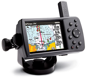
The GPSMAP 276C is an all-in-one, versatile, color chartplotter and automobile navigator � perfect for land or water. This portable GPS navigator features a 256-color TFT display that's easy to read in bright sun along with a built-in basemap and auto routing to provide you with turn-by-turn directions to the marina for a day of boating.
On water, the GPSMAP 276C is a dependable, color chartplotter with a built-in Autoroute basemap enhanced by Garmin's marine cartography. It accepts pre-programmed or user programmed data cards with MapSource� BlueChart� for offshore detail or Recreational Lakes with Fishing Hot Spots� for detail of inland lakes.
In addition, the GPSMAP 276C supports external NMEA sources for water depth, water temperature, and water speed through two serial interfaces. The unit also features a new Course Deviation Indicator (CDI) � an advanced navigation tool commonly found on aircraft, but equally practical in the marine environment. The CDI quickly indicates if a boat has veered off course.
On land, the GPSMAP 276C�s Americas or European Autoroute basemap features interstates and major highways. With an optional automotive kit that includes MapSource City Select� software, data card, friction mount, and 12-volt power adapter with speaker, drivers can receive voice-prompted turn-by-turn directions to addresses and points of interest throughout the United States and Canada or Europe.
For map transfer or software updates, the GPSMAP 276C features a fast USB-PC interface. The unit is also powered by a rechargeable lithium-ion battery pack, or a standard 110-volt AC plug.
3.8-inch diagonal, 480 x 320 pixel, 256-color TFT screen with adjustable LED backlight
Unit dimensions: 5.7"W x 3.2"H x 1.9"D
Adjustable marine mounting bracket
Stores up to 3,000 user waypoints, 50 reversible routes (300 waypoints per route)
10,000 point automatic track log; 15 saved tracks
Rechargeable lithium battery offering 5-15 hours of use (depending on backlight settings)
WAAS-enabled, 12 parallel channel GPS receiver
Adjustable quad helix receiving antenna with remote antenna capability
Built-in basemap with automatic routing and turn-by-turn directions
Accepts standard Garmin data cards and pre-programmed data cards
Provides separate serial and USB interfaces
2 NMEA serial ports
Offers BlueChart night mode for easier viewing at nighttime
Large numbers option for easy viewing
Position formats include Lat/Lon, UTM, Loran TDs, Maidenhead, MGRS, User, and more
Provides a course deviation indicator when navigating
Project your position on the map with the configurable complex heading line
Built-in tide tables and celestial tables for sun and moon calculations
Alarms: anchor drag, arrival, off-course, proximity waypoint, and clock
Water resistant to EC 60529 IPX7 standards (submersible in one meter of water for 30 minutes)
| Pack # |
Garmin GPSMAP 276 Color - Select your package and add any accessories you want. |
|
Standard
| GPSMAP 276 Color This package is shipped with the Garmin GPSMAP 276 Color and the package accessories listed below just as you purchase it in stores. | Garmin Retail:
$746.65*
Our Price $588.00 |
|
Order via ground today and get a free upgrade to FedEx Express Saver 2-3 day service nation wide. |
| Everything we sell is purchased directly from the manufacture. |
Package Accessories included with the 276 Color
GPSMAP 276C
One year Garmin warranty
Americas Autoroute Basemap
USB-PC interface cable
Power/data cable
Marine mount
Rechargeable lithium battery pack
AC adapter
Trip & Waypoint Manager CD
Manual
Quick-start guide
Additional information from Joshua P. Gooch at Georgia Power:
We need Gavin S., Wayne W., Randy B., Tom D., Chris C., Greg W., Perry D., Hugo P., Fernando R., Nason S. need to purchase the 276 GPS and Pack 1.
We need Shelby W., Tracy M., Amir K., Craig U., Kyo K. Gary M., Don C., Keith R., Jeff H., Jose R. need to purchase the 276 GPS and Pack 2 (4 accessory items).
|