|
|
|
Accessories
|

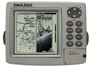
FishElite 480 GPS/Fishfinder

The FishElite™ 480 is the topflight 480x480 recording sonar/GPS+WAAS/mapping combo. It has it all, with superior resolution, target separation and power! |
 |
|
Features
Display:
- 5" (12.7 cm) diagonal screen
- Film SuperTwist LCD
- High-definition 480x480 resolution
- Amber LED backlit screen and keypad
- 16-level grayscale
Sonar:
- Digitally record/play sonar graphs and GPS trip details with optional,
reusable compact Multi-Media Cards
(MMC) or Secure Digital (SD) memory cards. One waterproof slot for
instantly-expandable memory using a single 8MB-512MB card
- Depth capability to 800 ft* (244 m) with 1500 watts of peak-to-peak power
- High-performance, low-profile 200 kHz Skimmer® transducer with built-in
temp sensor delivers up to 60° of fish detection area with high sensitivity settings -
Operates at boat speeds up to 70 mph (61 kts)
- Trolling speed and distance log readings available with purchase of
an optional sensor
- FishReveal™ feature exposes fish targets hidden
in surface clutter, weed beds, thermoclines, and other types of underwater cover
- HyperScroll™ feature locates and displays fish targets at higher boat speeds
- Advanced Signal Processing (ASP™) automatically adjusts
your settings for the best sonar picture
- Patented GRAYLINE® separates fish from nearby structure and bottom
- Advanced Fish I.D.™ shows underwater targets in different sizes
of fish symbols
- FishTrack™ displays target depth readings above fish symbols
- Surface water temperature readings come from a built-in temp
sensor in the transducer
- Zoom with zoom bottom tracking and easy zoom-in/out control
- Selective on/off sonar alarms: Shallow, Deep, Fish and Zone
GPS+WAAS:
- 12-parallel channel GPS reception with fast, strong satellite lock-ons,
precise tracking, and position updates every second
- Selectable on/off WAAS reception for enhanced position accuracy to 3 m (under 10
ft) at select locations
- All-new, built-in Eagle® background map with enhanced
continental U.S. and Hawaii detail including nav aids
- High-speed map screen updates
- Optional GPS Mapping Accessories Pack with MapCreate™ CD software that:
- Lets you create unlimited, custom, detailed maps on MMC
or SD memory cards
- Includes unique, searchable database of streets, addresses, and over
700,000 Point-of-Interest (POI) to easily find/identify marinas,
restaurants, airports, emergency services, and more
- Saves up to 1,000 waypoints, 1,000 event markers, and 100 routes
(up to 100 waypoints/route)
- 100 savable plot trails with up to 10,000 points per trail
- 42 graphic icons to mark your favorite spots
- 37 map zoom ranges - from 0.05 to 4,000 miles - with easy zoom-in/out control
- Compatible with optional Navionics® CLASSIC™, GOLD™, and HotSpots™ electronic charts
on MMC cards
Performance:
- Internal back-up memory keeps stored GPS data and sonar settings safe and accessible
for years
- Completely sealed and waterproof, even for use in harsh saltwater environments
- Full one-year warranty
|
| Pack # |
Eagle FishElite 480 - Select your package and add any accessories you want. |
| Pack #1 | This package is shipped with the Eagle FishElite 480 GPS/Fishfinder, and the package accessories listed below. |
|
|
Package Accessories Included
FishElite 480 GPS/Fishfinder
One Year Warranty
GPS Module with WAAS
Gimbal Mount and Knobs
Power Cable
200 kHz Transom Mount Transducer
Transducer has Temp and Depth
(1500 watts peak to peak)
Owner's Manual
Quick Reference Card
|
|