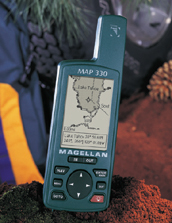
The Ultimate Mapping GPS Navigator |
|
Boasting the most memory
in its class, the MAP 330 is designed to meet stringent navigation needs of the outdoor
enthusiast and mobile professional who demand superior reliability and functionality.
The built-in 8-megabyte
base map includes worldwide political boundaries and U.S. cities, highways, major roads,
national parks, airports, waterways, and railways.
It also includes
8-megabytes of FLASH memory (rewritable) that allows use of the optional MapSend Streets™
CD-ROM. This software provides the user with comprehensive street detail for
superior navigation capability. Currently available with maps of North America only.
View your navigation
information on any of the four graphic screens presented on a high-resolution display for
a clear picture of where you are and where you’re headed. With a powerful
12-parallel channel receiver and quadrifilar antenna, the MAP 330 provide outstanding
lock-on tracking in a vehicle, boat or on foot.
Across town or across the
ocean, the MAP 330 is the ultimate navigator.
The
Magellan Advantage
- Powerful 12-parallel channel
receiver and super sensitive quadrifilar antenna for fast satellite signal locking and
accurate tracking.
- Built-in 8-megabyte map database
displays major roads and highways, cities and other navigable details with advanced map
database search.
- 8-megabyte’s of FLASH memory.
- PC Upload/download capability for
additional street detail via the MapSend Streets� CD-ROM.
- One Year Warranty
Features
- Powerful 12-parallel channel
receiver
- 500 waypoints, 20 reversible routes
with 30 legs
- High resolution grayscale display
(104X160 pixels)
- 4 easy-to-follow graphic navigation
screens
- Best fish and game time calculator,
proximity alarms, and sun/moon calculator
- 2-level EL Backlit display and
keypad
- Super sensitive quadrifilar antenna
for superior tracking
- 10-hour battery life on 2 AA
alkaline batteries
- Dedicated GOTO, NAV, MARK, MENU and
LIGHT keys for quick and easy operation
- Displays distance, bearing, heading,
steering, speed, time to go, elevation, XTE, time and satellite elevations
- 1200-point SmartTrack records your
path while BackTrack brings you home again
- Resettable trip odometer
- "EZstart" operation
- 9 coordinate systems:
Latitude/Longitude, UTM, OSGB, Swiss, Swedish, Irish, Finnish, French and German
- 73 map datums: NAD27, WGS84, AUST84,
EUROPE50, GRB36, IREL, KKJ, RT90, SAM69, SWISS, TOKYO, FRENCH and GERMAN
- NMEA data output for PC interface
- DGPS ready
- Rugged, durable, and weatherproof
– it floats!
- Pocket Size, 6.0" (h) x
2.0" (w) x 1.3" (d) / 15.75 cm x 5.0 cm x 3.3 cm
- Lightweight, only 7 oz (198.8 gm)
Ships
With
- PC cable
- Wrist strap
- User/Quick reference guide
Optional
Accessories
- MapSend Streets™ CD-ROM
- Leather and Canvas Carrying Cases
- Bike and Vehicle Mounting Brackets
- Swivel Mounting Bracket
- Power Cable w/ Cigarette Lighter
Adapter
- Power/Data Cable w/ Cigarette
Lighter Adapter
Suggested Retail Price $299.00
Our Price: $209.90
|