
|
|
Lowrance LMS-320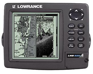
Deep-sounding 50/200 kHz sonar to 2,500 feet1 and precision GPS+WAAS chart recorder with super-sharp 320x320 pixel display and unique memory card versatility! Unique Standard Features: Patented high-speed, low-profile, transom-mount, 50/200 kHz Skimmer® dual-frequency transducer for excellent depth capability to 2,500 feet1 (762 m) and operates at boat speeds up to 70 mph (61 kts) Built-in temp sensor in the transducer; unit accurately displays water surface temperature Includes SP-X transom-mount sensor for precise trolling speed/distance log readings Digitally record/play sonar graphs and GPS trip details, plus display custom electronic charts with optional, reusable compact Multi-Media Cards (MMC) or Secure Digital (SD) memory cards Compatible with optional Navionics® CLASSIC™ and HotMaps™ electronic charts on MMC cards for select domestic and international areas, featuring depth contour lines and other helpful nav aids Sonar/Display Performance Features: 16-level gray scale definition and 102,400 total pixel resolution for incredible sonar and chart detail viewing, even in direct sunlight Brilliant fluorescent cold cathode backlit screen and keypad for easy readability at night and in low-light conditions Simplified keypad with Menu and Pages keys for easy on-screen features selection FasTrack™ full-screen flasher mode with GRAYLINE® displays instantaneous sonar returns, plus gives the relative signal strength of each target When displaying actual sonar returns, FishReveal™ feature shows fish targets hidden by surface clutter, thermoclines, weed beds and other cover in 16 levels of gray scale HyperScroll™ feature locates and displays fish targets at higher boat speeds Patented GRAYLINE® separates fish and important structure, on or near the bottom, from the actual bottom, and defines bottom composition /hardness Hands-free operation ease with Advanced Signal Processing (ASP™) that automatically adjusts all crucial sonar settings for the best possible picture in nearly all fishing situations Selective on/off Advanced Fish I.D.™ feature shows underwater targets in different sizes of fish symbols based on the relative signal strengths of the return echoes Selective on/off FishTrack™ feature displays target depth readings above each fish symbol as a guide for quick and precise lure presentations Programmable display feature lets you combine a panel of your favorite sonar data readings with your sonar graph in one easy-to-read display Multi-range split-screen zoom and automatic bottom tracking with high-speed display updates during depth range changes for uninterrupted viewing Instant zoom display ranges and zoom-bottom-tracking and easy zoom-in/out control Selective On/off Shallow, Deep, Zone, and Fish alarms Key GPS+WAAS Features: Selectable on/off WAAS reception for enhanced position accuracy to 3 m (under 10 ft) at select locations All-new, built-in Lowrance background chart with enhanced detail of the continental U.S. and Hawaii. Includes over 60,000 critical nav aids and 10,000 wrecks and obstructions in coastal and Great Lakes waters, as well as metro areas, select major streets/highways, interstate exit services detail, and more for inland navigation High-speed screen updates Optional GPS Mapping Accessories Pack with MapCreate™ CD software2 lets you create unlimited, custom, detailed charts on MMC or SD memory cards for LMS-320DF navigational display. Includes unique, searchable database3 of over 700,000 Points-of-Interest to easily find/identify restaurants, airports, emergency services, and more Mega-memory saves up to 1,000 waypoints, 1,000 event markers, and 100 routes (up to 100 waypoints per route) 10 savable plot trails with up to 10,000 points per trail 42 graphic icons to mark your favorite spots 37 chart ranges - from .05 to 4,000 miles - with easy zoom-in/out control Selective on/off GPS alarms: Off Course, Arrival, and Anchor Comfort Features: High-impact cover protects screen and keypad when not in use Completely sealed and waterproof, even for use in harsh saltwater environments Full one-year warranty Dimensions: THIS PRODUCT HAS BEEN DISCONTINUED.
|

Package Accessories Included
LMS-320 FishFinder
One Year Warranty
Gimbal mount with knobs
Protective cover
Power/data cable
Owner's Manual
Quick Reference Card