|
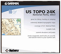
| United States TOPO 24K National Parks, West
|
 |
Let MapSource® U.S. TOPO 24K National Parks, West help plan
your next outdoor adventure. This CD contains digital topographic
maps in the Western U.S., including Hawaii, that are comparable
to the 1:24,000 scale paper charts provided by the U.S. Geological
Survey. This is the
most detailed
topographical data available from government sources. |
Features include:
- Trip and waypoint management functions**
- Highways, roads, hiking trails, snowmobile
trails, backwoods trails, 4x4 Jeep trails, elevation contours,
point elevations, summits, geographic names, cliffs, ridges,
rapids, and geysers
- Shoreline detail for lakes, reservoirs,
small bodies of water, waterways, rivers, and streams
- Icons representing boat ramps, dams, marinas,
campgrounds, public facilities, mile markers, first-aid stations,
visitor centers, and picnic, swimming, and ski areas
- Icons representing park facilities with
a viewable list of amenities
- Vector-based cartography
- Routable trails
- Ability to select coverage by quad, with
the ability to view quad and correlating park name for easy
reference on your paper map
**These functions of this product work with nearly all Garmin®
GPS units, excluding the GPS100 family and panel mount aviation
units. Some units may require a Garmin data card to upload map
data.
Coverage Map
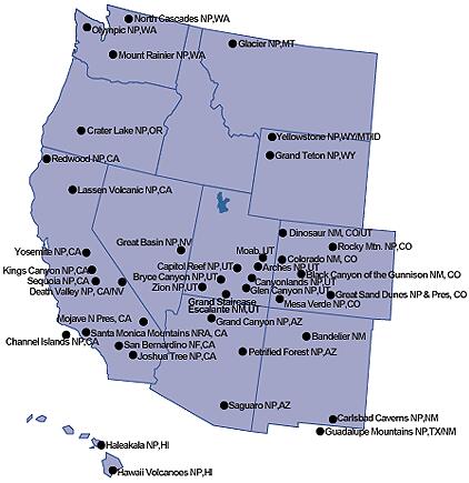 |
U.S. TOPO 24K National Parks, West includes:
- Arizona
- Grand Canyon NP
- Petrified Forest NP
- Saguaro NP
- California
- Channel Islands NP
- Death Valley NP
- Joshua Tree NP
- Lassen Volcanic NP
- Mojave NP
- Redwood NP
- San Bernadino NF
- Santa Monica Mountains NRA
- Sequoia and Kings Canyon NP
- Yosemite NP
- Colorado
- Black Canyon of the Gunnison
NP
- Colorado NM
- Dinosaur NM
- Great Sand Dunes NM
and Pres.
- Mesa Verde NP
- Rocky Mountain NP
- Hawaii
- Haleakala NP
- Hawaii Volcanoes NP
- Montana
|
- New Mexico
- Bandelier NM
- Carlsbad Caverns NP
- Nevada
- Oregon
- Texas
- Utah
- Arches NP
- Bryce Canyon NP
- Canyonlands NP
- Capitol Reef NP
- Glen Canyon NRA
- Grand Staircase - Escalante
NM
- Moab NP
- Zion NP
- Washington
- Mount Ranier NP
- North Cascades,
including:
- Lake Chelan NRA
- Ross Lake NRA
- Olympic NP
- Wyoming
- Grand Teton NP
- Yellowstone NP
|
Screen Examples
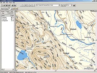
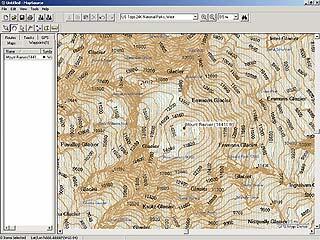
Use US Topo 24K to plan your outing by creating waypoints and routes on your PC, then downloading to your Garmin GPS. |
| |
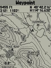 (GPSMAP 76 screen) |
| New US TOPO 24K data includes extremely detailed topographic maps that are ideal for hunters, hikers and outdoor enthusiasts. Topographic data is based on the 1:24,000 scale paper charts provided by the United States Geological Survey (USGS). |
|
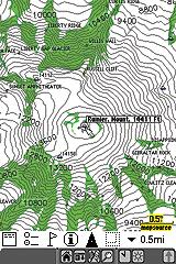 (iQue 3600 screen) |
Suggested Retail Price $149.99
Our Price: $89.00
|