|
  Features Features
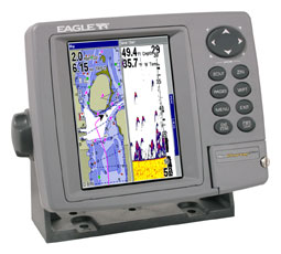
Display:
- Ultra-bright, 5" (12.7 cm) diagonal screen
- 256-color, enhanced TFT LCD
- High-definition 640Vx480H resolution
- Fluorescent cold-cathode backlit screen and keypad
- Unique Resize Window to adjust split-screen display
- Overlay Data feature displays GPS data on sonar screens and
sonar data on GPS screens
Sonar:
- Depth capability to 1500 ft* (457 m) with 4000 watts of peak-to-peak power
(500W RMS)
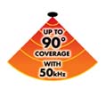
- High-performance, low-profile 50/200 kHz Skimmer® dual-frequency transducer with built-in
temp sensor delivers an extra wide angle of fish detection area with high sensitivity settings -
Operates at boat speeds up to 70 mph (61 kts) - Variety of other
transducer purchase options available
- SP-U transom-mount sensor included for precise trolling
speed/distance log readings
- Adjustable ping speed with automatic HyperScroll™ to display fish targets at higher boat speeds
- Choice of six color display modes to match outdoor light
conditions, and to help reveal fish hidden in underwater cover
- FasTrack™ vertical bar flasher displays real-time sonar returns
and relative strength of each target
- Advanced Signal Processing (ASP™) automatically adjusts
your settings for the best sonar picture
- COLORLINE™ separates fish from nearby structure and bottom,
and helps define bottom composition and hardness
- Advanced Fish I.D.™ shows underwater targets in different sizes
of fish symbols
- FishTrack™ displays target depth readings above fish symbols
- Surface water temperature readings come from a built-in temp
sensor in the transducer
- Zoom with zoom bottom tracking and easy zoom-in/out control
- Selective on/off sonar alarms: Shallow, Deep, Fish and Zone
Recording:
- Waterproof card slot for one MMC/SD memory card (not included) to record
sonar graphs and GPS data files, and to load high-detail electronic
chart options for nav display
- Compatible with optional plug-and-play Lowrance FreedomMaps™, Fishing Hot Spots® Elite, LakeMaster® Pro Maps, NauticPath™ Coastal, and Navionics® electronic charts on MMC/SD
cards
Chartplotter:
- Built-in, 12-parallel channel GPS+WAAS antenna
- WAAS-enabled for enhanced position accuracy to 3 m (under 10
ft) at select locations
- Custom, built-in background map with enhanced
continental U.S. and Hawaii detail including over 60,000 nav aids
and 10,000 wrecks and obstructions in coastal and Great Lakes
waters, as well as interstate exit services, and more inland
navigation features
- Optional GPS Mapping Accessories Pack with MapCreate™ CD software,
one digital media card, and an MMC/SD card reader/writer that:
- Lets you create unlimited, custom, detailed maps on reusable
digital media cards (MMC/SD)
- Includes unique, searchable database of streets, addresses, and over
2,000,000 Point-of-Interest (POI) to easily find/identify marinas,
fuel, restaurants, hotels, airports, emergency services, and more
- Saves up to 1,000 waypoints, 1,000 event markers, and 100 routes
(up to 100 waypoints/route)
- 100 savable plot trails with up to 10,000 points per trail
- 42 graphic icons to mark your favorite spots
- 40 map zoom ranges - from 0.02 to 4,000 miles - with easy zoom-in/out control
- High-speed screen updates
Performance:
- Internal back-up memory keeps stored GPS data and sonar settings safe and accessible
for years
- Rugged, reliable, completely sealed and waterproof casing, even for use in harsh saltwater environments
- Full one-year warranty
* Actual depth capabilities depend on transducer configuration and
installation, bottom composition and water conditions. All sonar
units typically read deeper in fresh water than salt water. |